The airspace, and a world to practise in.
Drones and autonomous vehicles need two things: the real space with its rules, and a world in which every mistake can be made safely. Official and open geodata are the basis for both.

The film shows drone geo-zones as volumes over a city, a map of disrupted satellite positioning, the viewshed from a hill, the same WorldCrafter training world in four seasons and an assumed fire on a wooded slope.
- Where may you fly? Drone geo-zones with legal basis
- Where satellite positioning is disrupted. GPS interference
- Walk the operating area in advance. Viewshed over terrain
- A world to practise in. WorldCrafter · the same place through the year
- Play it through before it gets serious. Demonstrator · assumed fire on a slope
Trailer, 33 seconds: drone geo-zones as volumes, GPS interference, a viewshed, a training world through the year and an assumed fire on a slope. All footage taken from the product.
Plan, fly, train.
Flight planning, operations and development need the same space: once as it is today, and once as a world to practise in.
Rules and traffic in the airspace
- Drone geo-zones with the legal basis on click, as volumes with an altitude band.
- Manned air traffic from reported positions.
- GPS interference over real terrain.
Inspection flights and approvals
Walk the operating area in advance
- 3D terrain, buildings and viewshed.
- Sun position for light and glare.
- Official warnings and DWD weather.
Mission preparation
Training worlds with WorldCrafter
- 3D worlds from the geodata of real places for Unreal Engine 5.
- Seasons, weather conditions and synthetic sensor data per capture.
- Colour image, depth, class and thermal image from the same world.
Test and training data for autonomous systems
An inspection flight is being planned.

Drone geo-zones stand as volumes with their altitude band above the terrain, with the legal basis on click. Manned air traffic and GPS interference are added.
Where you may fly, where approval is needed and what is in the air right now are in one picture over real terrain.
- Drone geo-zones with the legal basis on click
- Reported aircraft across Germany
- Your planned flight routes as a layer
Where is satellite positioning disrupted?

With every position report, aircraft state how accurately they know their location. SovAtlas evaluates this for areas of about 1,900 km² each: the share recently disrupted, as a moving window of 15 minutes, updated every minute.
Drone pilots see before take-off whether positioning in the area has recently been unusual.
- GPS interference over Germany and neighbouring countries
- Notes on interference along your route
Walk the operating area in advance.

3D terrain, buildings and the viewshed from any point, with an observer at 2 to 500 metres, plus the sun position for light and glare.
Take-off site, line of sight and obstacles are settled before the team is on site.
- Viewshed over terrain and buildings
- Sun position by date and hour
- Your operating area as a password-protected map for the whole team
A world in which you can practise safely.
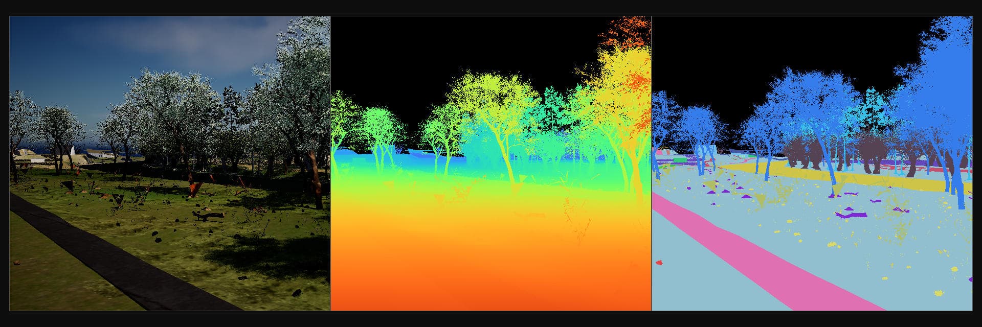
With WorldCrafter, the geodata of a real place become a 3D world in Unreal Engine 5, where drones and ground vehicles are tested and trained. The synthetic sensor data are produced in that world as well.
Sun, fog or snow: the right answer is known for every capture, so the cameras of autonomous systems can be checked and trained against it.
- Real places, 500 m or 1 km edge length, in four seasons
- Your test site as a training world, with your sensors
Your data in the same picture.
The map brings what is officially and openly available. Your routes, take-off sites and test areas are added, protected.
- Flight routes, take-off sites, test areas, points of interest
- Drone geo-zones, air traffic, GPS interference
- Official warnings, weather, sun position
- 3D buildings with height
- Terrain, aerial imagery
- Access per map, protected by password or personal access link.
- Open maps can be embedded in your application and controlled from it.
- Your routes and areas as a layer.
- Training worlds of your test sites with WorldCrafter.
What getting started looks like.
We show you your operating area in one picture and, if you wish, as a training world.
Demo
One hour, your area: geo-zones, air traffic, GPS interference, terrain and view.
Pilot project
A password-protected map for your operating area; defined scope, defined term.
Train
A training world of your test site with WorldCrafter, with seasons, weather and sensor data.
To take away and pass on.
Topic sheet: Drones and training
Two pages to pass on: geo-zones, satellite positioning, the operating area and training worlds with WorldCrafter, shown with examples from the product, plus how to get started.
Technical details of WorldCrafter
Places, edge lengths, weather conditions, materials, classes and sensor images of a training world at a glance. We are happy to send you the details.
Which area should we show you?
In a demo we show SovAtlas on your operating area and WorldCrafter on a training world.